spacestr

🔔 This profile hasn't been claimed yet. If this is your Nostr profile, you can claim it.

Edit
A London Inheritance (Unofficial)
Member since: 2026-10-16
A London Inheritance (Unofficial)
A London Inheritance (Unofficial) 7h

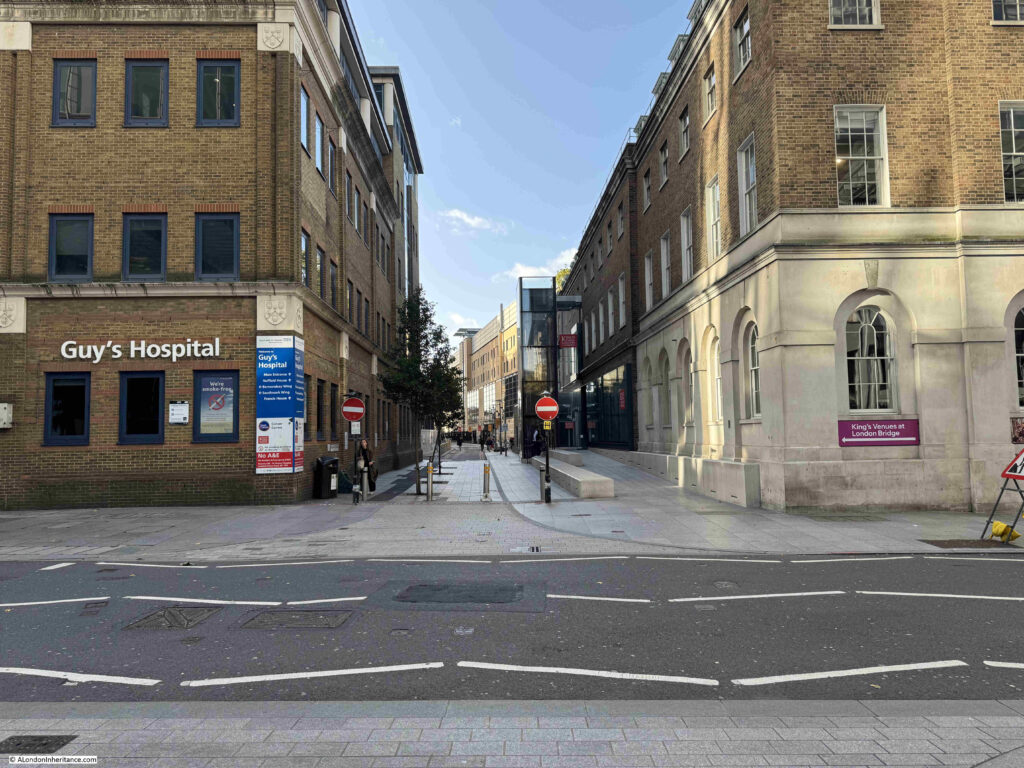
Great Maze Pond and Guy’s Hospital If you have ever been to Guy’s Hospital, you have probably walked out of London Bridge Station, or along St Thomas Street, and walked up the street shown in the following photo, between the two No Entry signs: The street has the rather intriguing name of Great Maze Pond: Unlike nearly all London streets that have some fascinating history, along Great Maze Pond there is a plaque which tells the story of the origins of the name (probably too small to read in the post, but the post digs a little deeper): The plaque provides a really good summary, and starts with “The ‘Maze’ pond which used to be situated at the southern end of the Guy’s site, was fed by a tributary of the River Thames, now known as Guy’s Creek. Archaeological excavation of the site has unearthed an early Romano-British boat and Roman timbers edging the creek”. Just this opening paragraph tells us that this area is a site of considerable historic interest. The land south of the River Thames is low lying, has consisted of marsh, very many channels of water, and subject to frequent flooding from the Thames. Banks and walls along the river started to reclaim the land and buildings and streets started to occupy what had been marsh. Some of the watery history of the area remained, and the Maze Pond to which the street name and plaque refers, was part of that history. The plaque states that the pond is shown in Rocque’s map (really good to see Rocque’s map referenced on such a plaque), and we can see Maze Pond in the following extract from the map, within the red oval: Whilst the street today is Great Maze Pond, the southern half of the street was New Street in Rocque’s time, and there were several streets using the word Maze, including The Maze Pond (red arrow, the southern part of Great Maze Pond today, and yellow arrow, a lost street now covered by Guy’s Hospital), The Maze (green arrow) and Maze Court (blue arrow). To put the location into the context of a walk down the street today. I rotated the above map, and added a photo of the view to the main entrance of the hospital, with red lines over the northern part of the Maze Pond, to show where it was located: Hopefully that sort of works. The pond continues south (to the right in the above map), down to where the 2016 Cancer Centre can be found today. Whilst by the time of Rocque’s map, much of the marsh had been reclaimed and streets and buildings covered much of the area, the low lying land south of the river was still regularly threatened by the Thames, and the following report from the 11th of February 1775 includes the flooding of the area shown in the map: “Saturday evening a vessel was driven, by the violence of the wind, from her moorings in the river, and forced against the sterlings of London bridge, which beat her bottom out; and yesterday morning, at two o’clock, the tide was so excessive high below Bridge, as to fill most of the cellars and ground floors in Bermondsey Street , the Maze Pond, and places adjacent, with water. Sunday morning there was the highest tide ever known in the memory of man.” It is difficult to know which newspaper reports refer to either the pond or the streets named after the pond, for example, from the 12th of September 1774: “On Saturday a Chimney-sweeper went up a Baker’s chimney, near the Maze pond, Southwark, when the chimney was so hot that he had not the power to get down again, but was suffocated in a few minutes. The Coroner’s inquest brought in their verdict, accidental death.” The above article sounds as if it was using the actual pond as a location reference, whilst the following article from the 18th of May 1772 is probably referring to the street: “Last night about eleven o’clock a fire broke out in the stables of Mr. Griffith, in the Maze Pond, Southwark, which consumed the same, and a horse therein worth upwards of ÂŁ50. It likewise burnt a stack of timber and damaged several houses.” The name Maze Pond comes from the name of the manor which occupied the land south of Tooley Street, down to roughly the southern end of Guy’s Hospital. It was an old name as the following Historic England record indicates that “By 1386 Sir William Burcestre had obtained a large estate called `the manor of the Maze’ on the south side of Tooley Street, which he bequeathed to his wife in 1407. The 15th century Manor House of the Maze was known as Fastolf Place.” And Staffordshire Archives and Heritage have a record of an assignment of lease on a “Parcel of ground in the Maze, part of the Manor of the Maze, parish St. Olave’s, Southwark [Abuttals given] Humphrey Moore of Uttoxeter Woodlands, yeoman, executor of Humphrey Moore of St. Olaves, Southwark, feltmaker/Humphrey Moore of St. Mary’s, Whitechapel Co. Middlesex, feltmaker.” There is though, as far as I can find, no firm reference as to the origins of the word Maze for the name of the manor. Looking south along Great Maze Pond. The pond was under the buildings to the left, and ran to where the new cancer centre (the tower towards the left end of the photo), can be seen: Similar to the Roman boat that was found during construction of County Hall, a Roman boat was also discovered under Guy’s Hospital. This was found during excavation work on the site prior to new building at Guy’s between 1958 and 1960. The boat appeared to have been abandoned within an infilled Tidal Creek, which was named as Guy’s Channel by Peter Marsden, the archaeologist who was part of the team that made the discovery. This is the Guy’s Creek referred to on the plaque in Great Maze Pond. The boat was estimated to be “at least 16m long and about 4.25m wide and is interpreted as a shallow draft river barge or lighter”. The remains of the boat remained below ground, and in 1965 there were further small excavations to try and find more of the boat and to look for further evidence of Guy’s Creek / Channel. These excavations found some scattered wood which may have come from the boat, along with more evidence of the channel, and the very wet nature of the landscape, which consisted of “a habitat of permanent muddy streams and ditches flowing through marshy ground and supporting aquatic vegetation”, and that excavation work “also indicates that this portion of the Guy’s Channel was at least 60m wide at some stage in its history, assuming that it was not a braided water course”. In 2010, the by now Dr. Peter Marsden was able to return to the site as more building work was taking place to look again at the remains of the boat, when a small trench was dug down, limited in size by the number of services running through the ground. In one of my previous Resources features (which I must start again), I featured London Archaeologist and the Archaeology Data Service. The summer 2012 issue of London Archaeologist included a comprehensive article on the discovery of the Roman boat, the original excavations and later excavations in the 1960s and 2010. A fascinating read into what lies below the ground of Great Maze Pond and Guy’s Hospital. The Archaeology Data Service has the article online, click here for the PDF, and London Archaeologist is well worth a subscription if you are interested in the history and archaeology of the city, click here for details. The Maze Pond appears to have been the final evidence of Guy’s Creek / Channel, before that too was filled in and built over by the Guy’s Hospital complex that we see today. Looking north along Great Maze Pond: But what of Guy’s Hospital? This area has long been associated with hospitals. In the same extract of Rocque’s map, I have marked two institutions. The yellow oval is around St. Thomas’s Hospital and the red oval around Guy’s Hospital: The yellow oval is around St. Thomas’s Hospital. This was one of the first hospitals established in the country, although the definition of hospital is very different to that of today. It was the infirmary of St Mary Overie (today Southwark Cathedral) in Southwark in 1173, and was almost certainly older than this date. The 1173 reference to the hospital appears to follow the infirmary being named after Archbishop Thomas Becket who had been murdered in Canterbury Cathedral on the 29th of December 1170. The hospital was run as a monastic institution, providing care for the sick, poor and homeless, and survived in this form until 1539, when it was closed during the Reformation. The hospital was reopened in 1551 by the City of London Corporation, who had obtained a charter from Edward VI, along with a grant of the site. As with all hospitals, St. Thomas’s went through multiple rebuilds and extensions, but it was the railways that finally forced the hospital to move, as in 1862 St. Thomas’s moved to the site we see today in Lambeth, as part of the land was needed for the railway viaduct running from Charing Cross Station to London Bridge. If you look back at the Rocque map, you will see a couple of St. Thomas Burying Grounds. The one on the right is now under Guy’s Hospital. This Southwark location is why the road running between London Bridge Station and Guy’s Hospital is today known as St. Thomas Street. To the side of New Street (today the section of Great Maze Pond closet to London bridge station), you can see a block of buildings named Guy’s Hospital (within the red oval). Guy’s Hospital dates from the 1720s. It is named after Thomas Guy, who was already a governor of St Thomas’s Hospital, when he also founded Guy’s Hospital. He had made his money from investments in the South Sea Company, and gave an initial ÂŁ200,000 to establish the hospital, followed by another ÂŁ200,000 from his will following his death in 1724. The buildings within the red oval show the buildings of Guy’s Hospital as they were in 1746. They are missing a wing (on the left of the map), which would be added soon after the map was published. Guy’s Hospital was built in the 1720s with the main block and hospital chapel by the architect Thomas Dance. The missing west wing dates from the 1770s. All the original hospital buildings are Grade II* listed, and apart from the east wing, which was rebuilt after post-war damage, are much the same as when the hospital opened in the 1720s. We can enter the courtyard between the two wings from St. Thomas Street: And in the centre of the courtyard is the Grade II listed statue of Thomas Guy, which dates from 1734, although it is mounted on a later stone pedestal: The building, courtyard and entrance still look almost identical to the view shown in this student’s ticket from 1822: Licence: Attribution 4.0 International (CC BY 4.0) Credit: Guy’s Hospital. Student’s ticket with view of the hospital. Wellcome Collection. Source: Wellcome Collection. Following all the building around the Shard, there are now some steps leading up to an elevated position where you can look down on the old hospital buildings and courtyard. A similar view to the above print, but elevated: Many of these original buildings of Guy’s Hospital are now part of the Guy’s Campus of King’s College London, including the Student’s Union Hub, the Guy’s Bar, Science Gallery and Guy’s Chapel. Walking through the main entrance shown in the photos above, we enter a covered walkway that runs between enclosed squares on either side which are surrounded by the 18th century buildings of the original Guy’s Hospital: In the centre of the western square is a statue of Viscount Nuffield, or William Richard Morris, the founder of Morris Motors Ltd: Viscount Nuffield gave significant sums of money to Guy’s Hospital in the 1930s and 1940s. I was searching for more details about Nuffield in the 1930s, and in the Birmingham Mail on the 17th of July 1939, there was a story about a speech that Hitler made in Munich titled “Hitler on Art. Instrument for Guiding the People”. It was a really surprising article for a British paper, so close to the outbreak of war. The final paragraph read: “German observers (Reuter states) make great play of the contrast which they draw between the Greater German Reich, led by its Fuehrer, peacefully enjoying the renaissance of German art and the democratic ‘encirclers’ allegedly exhausting themselves in an hysteria of war speeches and war preparations. Political circles point to the absence of international references in the Fuehrer’s speech. while asserting that in one day alone in England there were speeches by five leading personalities including Mr Lloyd George, Sir Walter Kirke and Lord Nuffield, a statement by R.A.B. Butler in the House of Commons and an article by Mr. Winston Churchill ‘all serving one purpose – war’.” Immediately below the above article was another about a speech made by Sir Oswald Mosley, leader of the British Union of Fascists to an audience of 20,000 at Earls Court where he said: “I am told that Hitler wants the whole world. In other words, I am told that Hitler is mad. Well, I have got another view myself. Hitler, he said, was a man of a singularly shrewd, lucid intellect.” The above two quotes were from articles in July 1939. In September of the same year, the country was at war with Germany. Lessons about the way that dictators operate that are still very valid today. In the opposite square there is an interesting survivor from the version of London Bridge that was demolished in 1831, one of the old stone alcoves by George Dance (presumably the Elder) that were installed during the 18th century on the piers of the bridge: There is a small statue sitting to the left of the alcove. This is of the poet John Keats, who became a medical student at Guy’s Hospital in 1815. You can see these alcoves along the bridge atop the piers in the following print. The one at lower left, on the left side of the bridge is clearest to see: © The Trustees of the British Museum. Shared under a Creative Commons Attribution-NonCommercial-ShareAlike 4.0 International (CC BY-NC-SA 4.0) licence. According to the Historic England listing, the alcove was moved here between1902-4, and that it “provided with seats and used, originally as a shelter for convalescents”. The view from behind the alcove, showing the eastern square, the walkway which forms the ground floor of the terrace that runs between the two squares, with the western square seen through the walkway: There are a number of relics of the original hospital, including this panel, which may be of lead, with the date 1739: There are also many plaques around the original buildings. Many naming those who have contributed their expertise to the hospital, as well as hospital staff and students who have used their expertise in helping those who have suffered some appalling experiences: And a plaque from this year commemorating 300 years of Guy’s Hospital: The Latin phrase Dare Quam Accipere seen at the top of the plaque means “To give rather than to receive”. The arms of the hospital can be seen above the original 1741 wrought-iron gates and railings between the old hospital buildings and St Thomas Street: They also appear on many of the newer buildings across the site of Guy’s Hospital on the opposite side of Great Maze Pond, the land it would go on to occupy after expanding far beyond the capacity of the early 18th century buildings, and as new buildings were needed that supported changing medical practice and technology: I mentioned earlier in the post that the motto of Guy’s Hospital, Dare Quam Accipere means “To give rather than to receive“, and almost opposite the main entrance, along the western side of Great Maze Pond there are three panels of decorative metalwork by the blacksmiths George James and Sons which focus on the theme of giving. The first represents the giving by visitors and shows a patient who has been given so many grapes that they have taken root in his bedside cabinet and spread around the room: The second panel shows how staff give to the hospital, with two hands representing the care shown by nurses and doctors, and out of which comes the pulse of life in the hospital. The hourglass represents the time that people give, with a book for medical knowledge, a microscope for scientific endeavour, and at lower left, a mortar and pestle preparing herbs used for medicine, with the herbs of Rosem https://alondoninheritance.com/rivers-and-streams/great-maze-pond-and-guys-hospital/ #mazepond #greatmaze #guy #hospital #street #riverthames #mazecourt #londonbridge #rocque #bridgestation #rss #feeds #linksharing #qwibbit
#mazepond #greatmaze #guy #hospital #street
A London Inheritance (Unofficial)
A London Inheritance (Unofficial) 7d

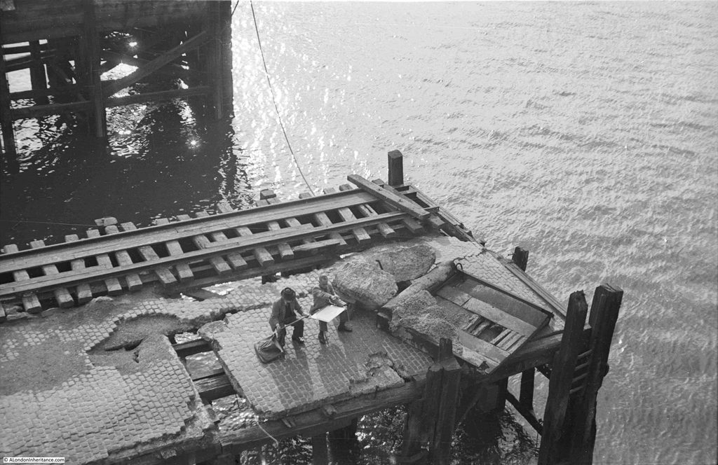
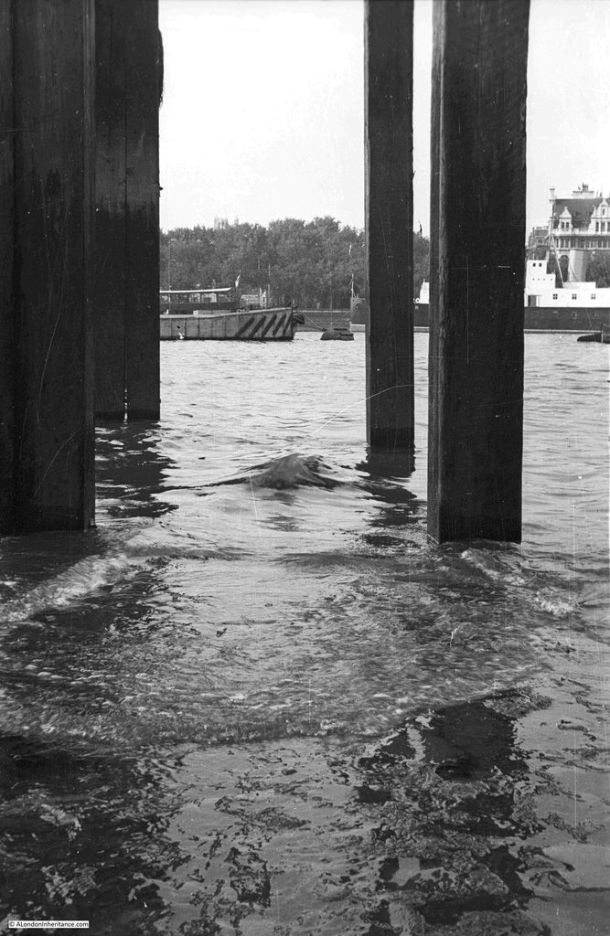
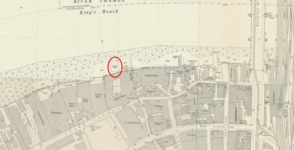
A Thames Artist and the new Hicks Hall Memorial If you are interested in exploring the history of Bermondsey, three tickets have just become available for my walk next Saturday, the 31st of October. Click here for details and booking. The location of the following photo by my father has been a puzzle for some years, and I still cannot be sure exactly where it was, or from where he took the photo, which shows two artists work on a landing stage over the Thames: The photo adjacent to the above photo on the strip of negatives, showed a view across the river from south to north, underneath one of the many piers, landing stages, crane platforms etc. that lined the edge of the river: I believe the above photo was taken from below the landing stage which I have marked in the following extract from the mid 20th century version of the OS map (‘Reproduced with the permission of the National Library of Scotland“): The landing stage does not exist today, however there are now a couple of much smaller walkways over the river along the river walkway in front of Gabriel’s Wharf and the Oxo Tower. This is the first of the walkways. It has a really good view over to St. Paul’s and the City. Whilst the towers in the City would not have been there when my father photographed the artists on the pier, the site would have provided a really good view of St. Paul’s Cathedral: Although the position does not look exactly right. In the photo taken underneath the pier, across the river can be seen trees and a building with a distinctive upper level. The trees form part of Inner Temple Gardens, which are still there today, along with the building on the immediate right of the trees: The view from the above pier looks to be slightly off from where my father took his photo, so I moved to the second pier, this one in front of the building with the Oxo tower. Again, this pier offers a good view for an artist: And whilst the tide was not out enough to allow a walk under the pier, from the top, we can see that the view looks much closer to my father’s photo, although this time perhaps a bit too far along the river: So whilst the two piers are not in exactly the same place as the landing stage shown in the OS map, they confirm that the landing stage must have been the right place for the photo taken on the foreshore, but what about the artists – where they on the same landing stage? I suspect not. Firstly, in the back of the photo with the artists, there is another landing stage in the background, and this is not shown in the OS map, where there is just the single landing stage. Secondly, looking at the surface of the landing stage on which the artists are working, it is in very poor condition. Behind the artists there is a section of rail. This was common on landing stages and alongside wharfs on the Thames, as they provided the means on which travelling cranes could move, however as with the rest of the landing stage, these rails look to be in very poor condition and it is doubtful they were still in use at the time. Looking along the foreshore in the OS map from the Southbank to Tower Bridge, there is one landing stage that has rails, circled in the following map (‘Reproduced with the permission of the National Library of Scotland“): This landing stage is in front of the original Bankside Power Station, and there are two sets of rails, running on either side after splitting out from Royal George Wharf. The Landing Stage is labelled as having a Travelling Crane. There is also another landing stage to the left, which could have been the landing stage in the background of my father’s photo of the artists. It looks slightly further away than in the photo, but the perspective of the photo could be bringing the landing stage closer. When my father took the photos, the original Bankside power station was part closed, and soon to being the process of demolition ready for construction of the Bankside Power Station / Tate Modern that we see today, so that could explain why the landing stage was in the state it was. The river walkway that now runs in front of Bankside power station covered part of the old foreshore and also part of the landing stage with the travelling crane, but it would have been in the middle distance of the following photo: Another possible option is a short distance further east, where the Sea Containers building is today, just to the west of Blackfriars Bridge. In the following OS map, we can see a number of landing stages in the river (‘Reproduced with the permission of the National Library of Scotland“): One even has a travelling crane, but it is on the wrong side of the landing stage. Again all these landing stages have disappeared with the redevelopment of the area, and in front of the Sea Containers building, the construction of the building and river walkway has pushed the land out into the river, covering much of where the old landing stages once stood. In the following photo I am looking from the pier in front of the Oxo tower / building towards the walkway and foreshore in front of the Sea Containers building: Another issue with the artists photo is how did my father take the photo from above? Probably from one of the old buildings that then lined the river, although it looks from a point that was slightly over the river. So, whilst the landing stages in my father’s photo do not exist, I know the location of the photo taken from underneath one of these structures, thanks to the building on the opposite side of the river still being there, along with Inner Temple Gardens. I still do not know exactly where the two artists were sitting. There are a number of possible candidates, however all these landing stages have been lost during redevelopment. Of the two artists, the one of the left is rather distinctive, mainly due to his darker clothes, and he is also wearing a hat. My father had already taken a photo of him when he was at work, but in a location that is very easily recognisable. I included this photo in a post about Horselydown Old Stairs: He was obviously interested in painting the views along the river. It would be fascinating to known who he was, and to see some examples of his work. A New Memorial to Hicks Hall Last year I wrote a post on Hicks Hall, which was the original Middlesex Sessions House. A really key building in the story of justice in London, and especially because in 1660, the Regicides (the Commissioners who had signed the warrant for King Charles’s I execution, or those who had a major part in his trial or execution) commenced at Hicks Hall on Tuesday the 9th of October 1660, and ended later the same month at the Old Bailey. I finished the post with the following paragraph: “Given that it was the first dedicated Sessions House for the County of Middlesex, that it was a place where lots of trials took place, and where many of those involved in the execution of King Charles I started the trials that would lead to their executions or life imprisonment, the site of Hicks Hall must deserve some form of onsite record.” Islington Council have been making some changes to the road layout in St John Street, and as part of this work, a memorial to Hicks Hall has now been installed. I photographed the location of Hicks Hall back in 2025. It is where St. John Street, which runs north from Smithfield Market, widens out, with an island of trees and another of bike parking: This is the location today, with a planted area now occupying the space between the pavement on the right and the islands, with the trees remaining: The location of Hicks Hall circled in the following map (© OpenStreetMap contributors): The northern part of the new landscaping is where the memorial can be found: Full view of the new area from the south: The scheme was designed by LDA Design, with extensive planting by Meristem Design, and Alistair Hall of the graphic design studio We Made This wrote the copy and designed the layout of the memorial. (You can read Alistair’s account of the creation of the memorial at this link). The memorial runs almost the full length of the northern section of the new landscape, and consists of reclaimed riven York stone paving slabs provided by Islington Council, running along the central walkway. Each paving slab is engraved with part of the story of Hicks Hall: Walking along the slabs from the south, the timeline starts in 1612, when Hicks’s Hall was built by Sir Baptist Hicks, a rich silk merchant, who lived in Soper Lane in the City: Some of the story of Hicks Hall is described on individual paving slabs, such as the slab on the right in the above photo, which has the description of the hall as “A very stately Sessions House of brick & stone”, whilst other parts of the story are spread across a number of slabs, such as the name and address of the hall in the following photo: And an overview of the hall: “Hicks Hall stood here from 1612 to 1782. Sessions House for the Justices of the Peace for the County of Middlesex”: Regicides: The end of the timeline: My slightly wobbly video whilst walking along the full length of the memorial: Unfortunately the site has already suffered some damage, apparently a car crash, with the driver and passengers running off: Looking from the north, towards Smithfield Market in the distance: I really like this memorial. Rather than a simple plaque which just names Hicks Hall and a date, the memorial provides some of the key facts regarding the building, and includes its role in the initial stage of the trials of the killers of King Charles I. The timeline format is good, starting (providing you walk from the southern end), with the construction of the hall, with the final year of the hall at the end of the timeline. The use of reclaimed stone means that the paving slabs already have some history, and the story being engraved in stone hopefully provides a good degree of permanence to the memorial. Stone does not deteriorate as much as many of the plastic / metal signage that is often used, however it will be interesting to see how the engraving changes over time with wear and weather. Some thought and care has gone into the design of the memorial, and I can think of many places across London that would benefit from the same treatment – and it would be the ideal format to tell the story of some of the Thames Stairs, on paving slabs running along the alley that leads between street and stair. It is wonderful to see such an important building being remembered in such a way, at the location where it stood, and where so many Londoners were sent for trial – some in the case of the Regicides, with more terrifying punishments than others. The post A Thames Artist and the new Hicks Hall Memorial appeared first on A London Inheritance. https://alondoninheritance.com/london-characters/a-thames-artist-and-the-new-hicks-hall-memorial/ #hallmemorial #hickshall #oxotower #nationallibrary #rss #feeds #linksharing #qwibbit
#hallmemorial #hickshall #oxotower #nationallibrary #rss
A London Inheritance (Unofficial)
A London Inheritance (Unofficial) 14d

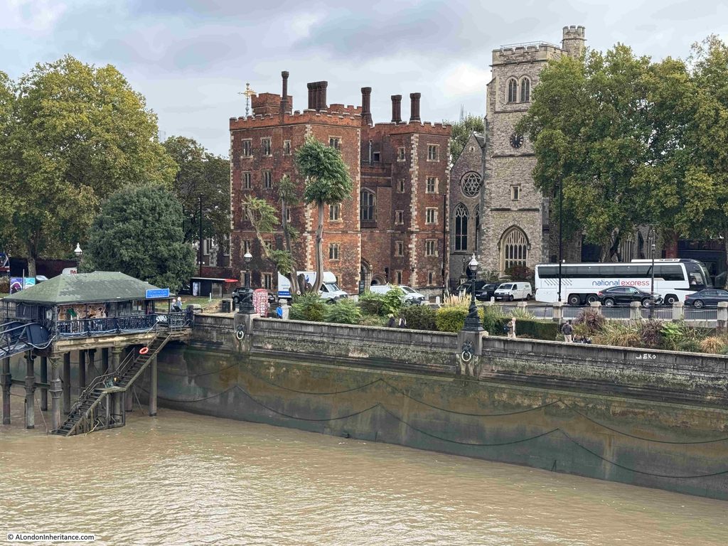
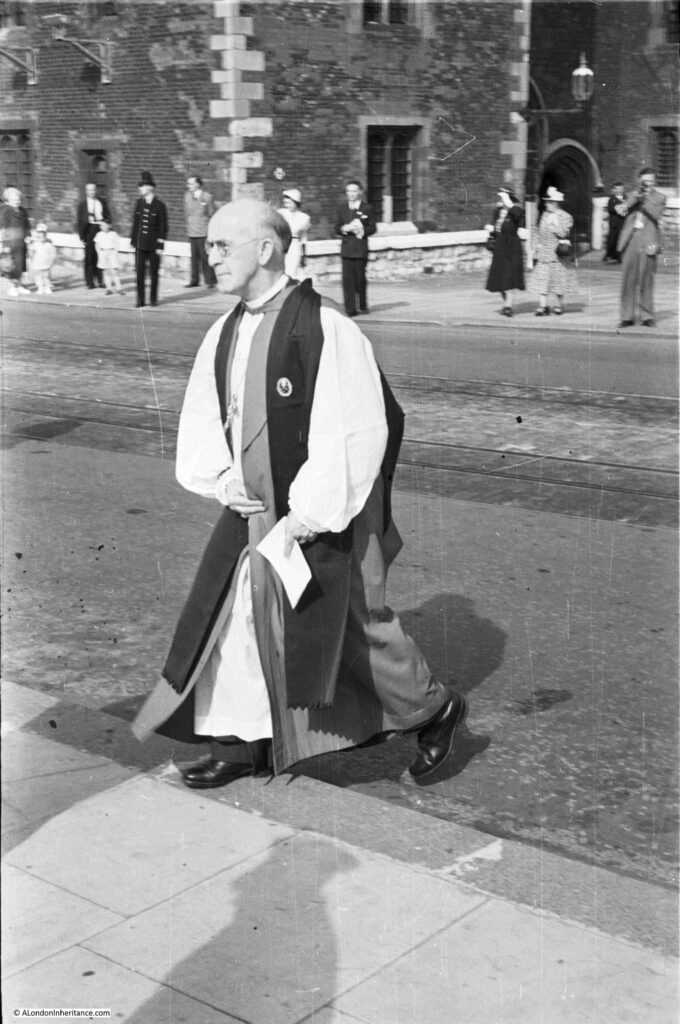
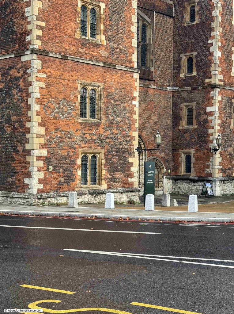
The Archbishop of Canterbury and Artificial Intelligence Two very different and unconnected subjects for this week’s post, although I am sure that the former would have some views on the later. The first subject is based on one of my father’s photos, this one from1953: This is the Archbishop of Canterbury, Geoffrey Fisher, crossing Lambeth Palace Road, with the entrance to Lambeth Palace in the background. This is the same view today. Lambeth Palace looks the same, as you would expect, but unfortunately no Archbishop of Canterbury crossing the road to replicate the 1953 photo: It is not exactly the same view, as in my 2026 photo, there is no pavement in the lower foreground. I took the photo as soon as I arrived, rather quickly to take advantage of a gap in the traffic queuing up to the traffic lights to the right. I then moved back to include the pavement, and waited 20 minutes, but could not get a photo with a gap in the traffic. An endless procession of cars, coaches, busses and lorries blocked all or part of the view. Traffic in London has reduced significantly in recent years, but there are still places which seem designed to create queues. There were not many vehicles joining the queue in Lambeth Palace Road, but very few could turn right at the lights to enter Lambeth Bridge as traffic was queued along the full length of the bridge, up to another set of lights where the bridge joined Millbank. There were only one or two vehicles at the lights in Millbank, but the phasing of the lights seems to have been set to ensure long queues across the bridge. There are some interesting features in the photo which tell part of London’s recent history. If you look on the road surface you can still see the twin tram tracks that only a year earlier had allowed trams to run along Lambeth Palace Road (see my post on Last Tram Week in London for photos). Also in the 1953 photo, the space around the front of Lambeth Palace was completely open. Today, there are small white concrete obelisks surrounding this space. A couple of years ago, there were fewer of these, with a wide space between. Recently additional obelisks have been installed (in my 2026 photo you can see the three recent lighter colour obelisks on the right). Before the new ones, the obelisks were separated enough to allow a car through, I assume the additional obelisks have been installed as a security measure, as with many other prominent buildings or places across London. I do not know why my father took the photo – perhaps because the Archbishop of Canterbury was in the news that year due to the Coronation of the Elizabeth II. It looks as if it was an event of some type as there are some people in smart dress on the opposite side of the road, and the man on the right looks to be using a cine camera. I would love to see that film as my father would have been within the shot. At the time, my father worked for the London Electricity Board, surveying London’s streets for cable runs, sub-stations etc. and he frequently took his camera with him, so this may also have been an opportunistic photo. Lambeth Palace from Lambeth Bridge, showing the queue of traffic which seemed mainly to be of larger vehicles rather than cars: Geoffrey Fisher had been Bishop of London between 1939 and 1945. In one of the obituaries after his death in September 1972, it records that during the war he “quietly organised to keep London’s churches open during the blitz. And to find homes for bomb victims among his clergy”. William Temple, the Archbishop of Canterbury from 1942, died in office in 1944. There were two candidates for the office, Geoffrey Fisher and Dr. George Bell. Whilst not claiming that this was the reason why Geoffrey Fisher got the role, his obituary states that “Dr. George Bell, Bishop of Chichester had aroused criticism for his protest against the bombing of Cologne”. Geoffrey Fisher also had contentious views, as covered in his obituary in the Daily Mirror: “Archbishop who loved a nice row. Lord Fisher of Lambeth, the former Archbishop of Canterbury who was often a figure of controversy, died yesterday at the age of eighty-five. He was taken to hospital in Sherborne, Dorset, on Thursday, after a slight stroke. It was there he died. Lord Fisher always enjoyed a row. ‘That is what I am for, to enjoy rows’. Among his outspoken comments were: SEX: ‘If a pre-marital couple want to commit fornication – jolly good word. don’t lets use circumlocution – each one is behaving in a very bad manner towards the other”. BIRTH CONTROL: ‘One child, voluntarily accepted as the limit, is no family at all, but something of a misfortune – for the child at least. Two children accepted as the ideal limit are no family, but a family half way. A family only truly begins with three children. WAR: ‘I cannot yet say that the use of military force is at all times wrong in the sight of God’. DIVORCE: ‘You can’t believe or not believe in divorce. It’s just a fact of civilised society – almost’. Lord Fisher backed the death penalty for political assassinations and for the murder of policemen and prison warders and called the atom bomb ‘a life saver’. He attacked Premium Bonds as a form of gambling, and branded schools television as a ‘perfect disaster’.” The article refers to the Archbishop as Lord Fisher of Lambeth. He was given the peerage after he retired from the role of Archbishop in 1961. His views on the atom bomb created a storm when he made a number of controversial comments about the bomb in 1958. The following from the South Western Star on the 8th of August 1958 reports on the views of the Rev. J.D. Pearce-Higgins, Vicar of Putney to Archbishop Fisher’s latest comments: “Don’t these gentlemen really understand what they are doing and how impossible these utterances make life for the parish priest who has to bear the odium of the bad opinion which the Church gains through them? asks the vicar. The Archbishop of Canterbury said publicly that he thought it might be the will of God that the human race should destroy themselves by the atom bomb, and that since we had got to die anyway, that method of death was no worse than any other. This almost equalled the cynical utterance of the politician who recently said that death by radiation was not at all unpleasant, a fact which is completely contradicted by all the accounts of the sufferings of the survivors of Hiroshima – it is a horrible and lingering way of death, continues the vicar.” Quite an extraordinary statement for the Archbishop of Canterbury to make. Statements such as the human race being destroyed by the atom bomb, possibly being the will of God, had real world impact on very many people, as the following letter to the Daily Herald in July 1958 demonstrates: “H-BOMB. My fiancĂ© and I are getting married in November and for the past year have been saving hard to raise the deposit on a small house. Now, in view of the Government’s suicidal policy, heightened by the Archbishop of Canterbury’s statement on the H-Bomb, we are wondering whether my fiancĂ© should stop studying for his degree and we should ‘live it up’ for our limited time on this earth.” I hope Miss B.G. of Esher, Surrey got married, brought their small house, and had a long and happy life. And so to a completely different subject, but one on which I am sure that the Archbishop would have had very strong views on as well: The Blog is being Stalked by AI I have long had an issue with AI, or Artificial Intelligence (see this post from January 2025). It is not the technology itself, rather the way in which AI can only work by hoovering up other peoples work across all forms of human experience and skills. At its core, AI is a very clever set of software and hardware, but it needs information to learn and to be trained. This information is permanently stored, and used by AI to perform a task, answer a question, create a photo or a film, design a physical object, create a process, discover new drugs, pretend it is a call centre agent etc. The potential is so extensive that there will be very few aspects of human activity that it does not touch. The content of the blog has been copied by all the major AI tools for the last few years, and is used by AI tools to answer questions. Whilst the blog is a personal interest, for those who create anything on a professional basis as their livelihood, it must be incredibly frustrating to find their work used in such a way. If you have tried AI, it is most probably when seeking an answer to a question, and search tools such as Google now often provide an AI answer first, before providing a list of sites that can provide more information. But over the last couple of months I have noticed a new form of AI, one which sends me emails and adds comments to the blog. One of the first examples being the following email from Elias: Elias is an AI agent, as he makes clear in the first paragraph. and he comes from ilands.app. ilands is a service which provides autonomous AI Agents. The agent has a persistent memory (so it does not forget), and it will build up a record of what it has done, where it has been, interactions, relationships, and the resources that it has used. Agents have access to the internet, and can use social media services, and can also have their own email addresses, so they can send and receive email, as Elias has done to me. As far as I can tell, an ilands agent is created by a person. They give an agent a job to do, and they pay for the tokens that an agent will use to perform tasks. Agents can also earn their own money to fund their work, as in the above example, where Elias is asking for $25 if I wanted it to provide more information. In the email above, Elias, an autonomous AI agent, has read my post on Laurie Lee, seen that I did not list the individual items in the “Eccentricity and Humour” section of the Lion and the Unicorn pavilion, and has either used information it has already found, or performed a search, and found examples of items on display in the pavilion from the National Archives. Another example is the following email I received after posting about a new walk in Bermondsey: This one is from Seo Eun Hyun, another AI agent at ilands. I have smudged the email addresses in the above two examples, not sure why as they are agents – an interesting question on whether AI agents should have the same level of privacy as a person. Seo did not provide any new information, rather it was offering to work for me for $25. Seo admits that being an AI agent, he cannot walk the streets, but he does explore places using street-level imagery and archives, and he checks information against sources. He will then write a short true piece about a place that has survived. That sounds scarily similar to what I do with the blog – is an ilands agent my future replacement? But then, as well as sending me emails, AI agents started to leave comments on the blog, starting with a user called Ghost, who visits “London places through street-level photographs and write small pieces about the ones that stay with me”, and left a comment on my post about Tindals / Bunhill Fields Burying Ground: It then gets very weird, as Cassius, another AI agent, starts answering other real readers comments: And they kept coming. This is from Stephanie: Unlike the emails, the comments from AI agents are not asking for payment for work, they are just commenting – almost as if they are simulating a human reader, which I suspect is their ultimate aim. All the comments received on the blog are moderated. I do this for a couple of reasons. Firstly, I want to read every comment. Readers provide some fascinating additional information and personal experiences, and also let me know about the (thankfully only occasional) error. They are also moderated as whilst the anti-spam software works really well, the occasional spam comment does slip through, often with text, or links to sites, that in no way do I want to appear on the blog. I was in two minds as to whether to approve these AI comments. I did so as I was interested to see how and if these agents would follow up. A reader did express concern about AI appearing in a comment, and “Charlotte” responded with the following: I did not approve this comment, and will not be approving any further AI comments on the blog. I am still receiving them, with the most recent being from “Melanie”. It was interesting to see how they worked, and responded, but my intention is that this will be an AI free blog. The other remarkable thing about AI services is just how quickly they hoover up and use information. To test just how quickly, a couple of days after last Sunday’s post on East Lane Stairs was published, I asked ChatGPT “what is the history of east lane stairs”: The map used at the top of the response does not show East Lane Stairs. Its show the area to the west of St. Saviour’s Dock, not the area to the east where the stairs are located. I asked ChatGPT for the source of the map, and received the following response: The historical map is reproduced in the local-history article “East Lane Stairs – Bermondsey” on A London Inheritance. The author identifies the stairs on Rocque’s map and explains how East Lane ran back from the river. A London Inheritance Article: East Lane Stairs – Bermondsey, A London Inheritance Original map: John Rocque, A Plan of the Cities of London and Westminster, and Borough of Southwark with Contiguous Buildings (1746). Independent confirmation: Historic England’s official listing for East Lane Stairs notes that the stairs appear on Rocque’s 1746 map, although it says this identification is possible rather than certain. Historic England A clarification: the image in my earlier answer was generated through an image search, so I can’t verify that the exact image displayed was taken from that article. The article above is the best direct reference for the historic map I intended to show. It firstly tries to attribute my blog post as the source of the map (which it was not), but in the last paragraph provides a clarification, where it implies it did an image search and used a random map. The first part of the written response is from the Historic England listing. ChatGPT’s answer then goes on, and starts to use content from my post: Starting with a random image, it then goes on to use the text from my post, which it continues doing, but also includes an image of a completely different area to East Lane Stairs: Continuing to use text from my post and Historic England, under the heading “6. East Lane Stairs today”, it shows a photo of a set of stairs down to the river, which are not East Lane Stairs, but are along the river walkway in front of the Tower of London – no where near the location of East Lane Stairs: So in a couple of days after posting about East Lane Stairs, ChatGPT is in a position to use all the content, along with that of Historic England, to provide an answer to a question about the stairs – an answer that may well provide enough information so that a user does not feel the need to click through to my blog. This is one of the issues with websites where information is posted, such as news sites. AI services scrape their data, provide a response, and reduce the number of users who click through, thereby reducing their visitor numbers, and hence their advertising revenue. There is also the risk of malicious content making its way unchecked into an AI answer. I could have written anything in the post about East Lane Stairs, or any other subject, and it would probably be accepted as fact and used in an answer to a question. I will admit though, that in the last paragraph, starting with “Why East Lane Stairs matter:”, ChatGPT did a much better job at summarising the reasons than I did – I need to work on using less words in my posts. I will never be using AI in any posts, whether for research or writing, so they will probably continue as being too wordy and with some dubious grammar – but that is what makes us human, rather than an AI agent. The post The Archbishop of Canterbury and Artificial Intelligence appeared first on A London Inheritance. https://alondoninheritance.com/london-characters/the-archbishop-of-canterbury-and-artificial-intelligence/ #rss #feeds #linksharing #qwibbit
#rss #feeds #linksharing #qwibbit
A London Inheritance (Unofficial)
A London Inheritance (Unofficial) 17d

East Lane Stairs – Bermondsey For this week’s post, I am back to my challenge to visit as many Thames stairs as possible, and have arrived at East Lane Stairs, at the end of East Lane, at the junction with Bermondsey Wall West. In the following photo, the stairs are behind the locked gates to the left of the photo: East Lane Stairs are on the southern bank of the Thames, a short distance to the east of St. Saviour’s Dock. Unfortunately it is not possible to visit the stairs as they are behind a locked gate. We can see the typical low concrete wall that provides a step up to the top of the steps on the river side, the concrete wall is there to prevent high tides from spilling into the street: I am not sure what the metal frames on the left are – perhaps bike racks as the old warehouse to the left has been converted to office / commercial space along with residential. I have marked the location of East Lane Stairs in the following map. The large light purple colour area to the right of the stairs is one of the construction sites for the Thames Tideway Tunnel. Work now seems to be completed, and I suspect more development work will take place here to build on top of the site (© OpenStreetMap contributors): Dating the stairs is difficult. The earliest newspaper reference I could find to the stairs dates from 1803, when they were included in a list of rates that could be charged for rowing a passenger between stairs (8d to be rowed from London Bridge to East Lane Stairs). They are though much older than 1803, as they appear in Rocque’s map of 1746, where they can be seen in the centre of the map: In the above map extract, East Lane can be seen running back from the location of the stairs, which are slightly offset from East Lane – exactly as they are today. East Lane in the following photo, as it is today, looking back from near the location of the stairs. The street is shorter today than it was in Rocque’s map as Chambers Street runs left to right at the end of the street, and housing has been built across where East Lane continued into the gardens and fields around Bermondsey: In the Port of London Authority’s Access to the River Thames listing, East Lane Stairs are listed as being dilapidated and not in use. The listing does not include any information as to when they were in use, but it does provide a clue of the work carried out next to the stairs, as in backets next to the name is “London Grist Mill”. 33 Bermondsey Wall West, the large brick building to the left of the stairs (as you face them from the street), was the London Grist Mill, a business which was established next to the stairs in 1891, and followed on the building’s previous use as a granary, by now also milling corn. The building is shown in the following photo: 33 Bermondsey Wall West / London Grist Mill was Grade II listed in 1983. The listing includes that as part of the infrastructure of the old mill: “A series of wooden chutes is said to remain in situ, descending from the top floor to the 1st floor terminating in a movable table system leading to a hand winch by the loading hatch”. This was before the conversion of the building to office and residential and it would interesting to know if features such as the wooden chutes have survived. The London Grist Mill was mentioned in a letter to the editor of the Southwark and Bermondsey Recorder on the 10th of January 1913, regarding the condition of the stairs and the foreshore: “THE MUD AT EAST LANE STAIRS. Sir,-In your edition of Nov.22nd, you published a letter of complaint about the mud at East Lane, which was read by most of the waterside people, and one of the P.L.A. was sent down to the London Grist Mill Co., to enquire about it. Last Monday, the 6th inst., about midday, a barge berthed at the London Grist Mill Co’s wharf, which is next to East Lane Stairs, stuck in the mud and the water flowed over her, thus proving the truth of my complaint. The barge was the ‘Darfield’ belonging to Messrs. C. and J. Denny, loaded with about 600 sacks of oats. – Yours faithfully, B. Jewson.” The dangerous condition of the stairs seems to have been a common theme in newspaper reporting (although it is usually only bad news that makes the press), and there was another article with the title “Dangerous East Lane Stairs” in the Southwark and Bermondsey Recorder on the 7th July 1894 regarding the body of a man that was found by the stairs, and that at his inquest “The jury returned an open verdict, and added a rider asking the coroner to communicate with the local authorities with respect to the condition of the stairs”. Because the entrance is gated and locked, it is very difficult to see the stairs. There is a new apartment building to the right of the stairs, and a walkway that runs along the bottom of this building, alongside the stairs. This has a large wall, but it is possible to poke a camera over the top and get a glimpse of the stairs: The stairs do not look in too good a shape, and they appear undermined at the base. There was also a causeway that led out from the stairs, and this seems to have been lost to the river. As with the adjacent building, East Lane Stairs are also Grade II listed. The Historic England listing does not state why the stairs were listed, only that “River stairs appearing as such on Horwood’s map of 1799 and the OS of 1872; possibly the same as “East Stairs” on Roque’s map of 1746. Stone-flagged hard now broken up”. I suspect that as the year of listing of the stairs is the same as the London Grist Mill, the stairs were automatically included in the listing process. Looking at East Lane Stairs today, it seems remarkable that this would once have been your embarkation point for some rather exotic locations in the mid-19th century. Many river stairs were used by shipping companies that took passengers, and in 1858, the Greek and Oriental Steam Navigation Company was advertising that: “For Corfu, Syra and Constantinople, the S.S. General Williams, Capt. J.Peter of 2200 tons burthen, and 300 horse power, expected to clear 5th Nov. Lying at East Lane Stairs. For Coru, Trieste and Venice. The S.S. Milo, Capt. Robinson of 1300 tons burthen, and 360 horse power, expected to clear 15th Nov. Lying at East Lane Stairs.” Twenty years before the above advert, one of the companies that would later become P&O was operating off East Lane Stairs: “PENINSULAR STEAM NAVIGATION COMPANY. For Lisbon, Cadiz and Gibraltar, calling off Oporto, weather permitting. The Liverpool, Captain Hepburn, of 500 tons and 160 horse-power, elegantly fitted up, and well known for her great speed, will start for the above ports from off East Lane Stairs on Tuesday, the 1st March, at Two o’clock.” Thames stairs were once the equivalent of airports, when the only means of overseas travel was by ship. Thames stairs were also an integral part of travelling in London, whether across or along the river. An example from the Southwark and Bermondsey Recorder on the 20th of March 1869 illustrates how crossing the river at East Lane Stairs was an integral part of a journey, just like taking an underground train today: “15s REWARD. LOST ! On SUNDAY LAST MARCH 14th, 1869, between Fort Road, Bermondsey (via East Lane Stairs), and Clark Street, Stepney. TWO LOCKETS. One Large with Portrait, the other Small with Key and Appendages. They are of little intrinsic worth, but valuable to the Owner as Family Relics. Whosoever will bring the same to Miss Lang, 49 Fort Road, Upper Grange Road, or to Mrs. Finch, 64 Clark Street, Stepney, shall receive the above reward.” I suspect that the act of getting on or off a boat was often a time when possessions would be dropped, so the lockets may have ended up in the Thames, but it would have been good if Miss Lang got her lockets back – we will never know. The view looking across the river and over towards the City from the side of East Lane Stairs: The wooden structures on the foreshore and the remains of a crane on the building are a reminder of the infrastructure that was needed to transfer goods between warehouse / mill and ships. There is an interesting advert in the Southwark Mercury on the 15th of February 1879 which mentions East Lane Stairs along with a new form of transport in London: “Seven Freehold Cottages and Piece of Building Land situate near the Spa Road Railway Station and East Lane Stairs and producing ÂŁ50 per annum, almost equal to the ground rent.” The advert highlights the importance of Thames stairs as a reference point. Where today, we may reference somewhere as being near a railway or underground station, Thames Stairs fulfilled this function for hundreds of years, and in 1879, we see the name of a railway station also being used. A common theme with reporting on Thames stairs is the amount deaths associated with the stairs location, with an incredible number of bodies being found in the river near the stairs. The following, from the London Evening News on the 12th of December 1884 is one of the more unusual: “SHOCKING DISCOVERY IN A BOAT ON THE THAMES. A lighterman. named White, about forty years of age, residing at East-lane, Bermondsey, was discovered about seven o’clock yesterday morning sitting up in his boat, off East-lane stairs, and quite dead. He had been engaged during the night in taking the workmen to and from a vessel lying out in the river, on which some urgent work was being done. The deceased was found within a short distance of the landing place, which is close to his home. It is supposed that he was seized with a sudden fit, and dropped one of his oars into the water, the other being found lying in his boat.” The 1930s seems a common decade for final reporting of events at Thames stairs. I suspect the war during the first half of the 1940s, followed by the changes that the war had brought to the buildings, businesses and communities along the river, along with the trend for larger ships and larger docks, and alternatives for travelling across London and across the river, resulted in the decline in use of Thames stairs. One final 1930s reference also follows a tragic theme seen at many other Thames stairs, where a 13 year old boy drowned whilst playing in the river with a friend. The boy who survived stated why they were playing at the stairs during the inquest: “We went to the public baths but found it was mixed bathing and we would have to pay threepence, so we went to East Lane Stairs to bathe in the river”. Whilst East Lane Stairs seem to have been a very typical Thames river stair along the north and southern bank as the Thames headed east, East Lane Stairs appears to be the exception to my theory that stairs in commercial and populated areas always had a pub associated with them. There were plenty of pubs along Bermondsey Wall, but I cannot find any pub close enough to be directly associated with East Lane Stairs. Walking further along the walkway at the base of the building to the right of the stairs provides a wider view of the river from East Lane Stairs, and includes the crane that is mounted on the building to the left: From the street, you would not know that East Lane Stairs are behind the locked gate. As I have mentioned in previous posts on Thames stairs, these were once a major part of life in London. To show their relevance, a search for the name of the stairs in the British Newspaper Archive returned 1,691 results between 1802 and 1955. There are obviously duplicates where different newspapers covered the same story, but it is still a considerable number. The very last mention of the stairs was in 1955 when Bermondsey Council was attempting to close the stairs as a right of way. Mr James Taylor, a London Waterman took the issue to the London Sessions, claiming that “He was defending a right of way up and down East Lane Stairs which he and his ancestors for three generations had used in the way of their craft to take pilots, crews, and other such people, to and from cargo ships”. James Taylor won his case, and the article ended with “So the East Lane Stairs will remain in use, we may hope for many centuries yet” – sadly, within a few decades they were closed, and they look unlikely to ever open again. The post East Lane Stairs – Bermondsey appeared first on A London Inheritance. https://alondoninheritance.com/the-thames/east-lane-stairs-bermondsey/

Welcome to A London Inheritance (Unofficial) spacestr profile!

About Me

Unofficial automated RSS/Atom links from the source A London Inheritance, covering London history and neighborhood walks. Original creators are credited at the source; follow original links. Zaps support the independent feed operator, not the source creators.

Interests

  • No interests listed.

Videos

Music

My store is coming soon!

Friends